

Picture a car idling outside a Shillong guesthouse at 8 a.m. on day three, and the traveler realizes they booked Dawki before Sohra, so now they face an 80 km drive back the way they came. That backtrack is the single most common mistake on any list of Meghalaya places to visit, and it costs the better part of a day. The fix is order, not more stops. This route runs Shillong to Sohra (Cherrapunji) to Dawki to Mawlynnong and back to Shillong across five days, roughly 350 km total and about 11 to 12 hours of driving spread over the loop. Among the Meghalaya places to visit, these four anchor towns connect into one clean circuit, and the sequence below keeps the trip moving forward the whole time.
The 5-Day Meghalaya Loop at a Glance
The route is a five-day clockwise loop: base in Shillong, drop southwest to Sohra (Cherrapunji), swing south to Dawki on the Bangladesh border, cut west to Mawlynnong, then climb back to Shillong. Total distance sits near 350 km, and the whole trip takes about 11 to 12 hours behind the wheel, so no single day feels like a marathon. This is a sequenced circuit built around drive legs, not a ranked count of attractions.
The Four Anchor Towns and Why This Order Works
Shillong is the arrival hub and altitude base. Sohra sits southwest with the waterfalls and caves. Dawki lies south with the Umngot River. Mawlynnong is a short hop west of Dawki. Running Shillong to Sohra first, then dropping to Dawki and Mawlynnong before the climb home, keeps every leg pointed forward. Most listicle routes send travelers back up to Shillong between each cluster, which doubles road time for no reason.
Leg-by-Leg Distances and Times
| Leg | Distance | Drive Time | Rain Adds |
|---|---|---|---|
| Guwahati to Shillong | ~100 km | 3 to 4 hrs | traffic on NH6 |
| Shillong to Sohra | ~55 km | ~2 hrs | 30 min on descent |
| Sohra to Dawki | ~80 km | 3 to 3.5 hrs | 30 to 45 min |
| Dawki to Mawlynnong | ~25 km | under 1 hr | minor |
| Mawlynnong to Shillong | ~90 km | 2.5 to 3 hrs | 30 min |
A flat top-30 ranking never shows these numbers. Order the loop and a traveler reclaims a full day that a checklist quietly wastes on doubling back.
Getting In and How to Move Between Stops
Travelers fly into Guwahati, in neighboring Assam, then drive to Shillong. That leg runs about 100 km and takes three to four hours depending on traffic on the NH6. Book the drive in advance or grab a shared cab from the airport. From Shillong, the entire loop runs by road, one leg per day, which is why pacing the drives matters more than any single viewpoint.
Hired Car Versus Self-Drive
A car with a local driver is the smart call. The rough patches near Dawki and the tight descent toward the root bridges reward someone who knows the road, and it removes the parking and navigation load entirely. Self-drive rentals exist, but signage thins out fast and mountain hairpins in fog are not the place to learn a new vehicle. A driver for five days is the cheaper mistake to avoid.
Where the Roads Get Rough
Three stretches slow travelers down more than maps predict: the final approach into Dawki, the winding descent past Sohra toward the plains, and the narrow trailhead roads near the living root bridges. Budget an extra 30 to 45 minutes on each in dry weather, and more in rain. For readers who plan destinations by distance and driving time, our Indian pilgrimage distance guides apply the same road-quality-over-raw-kilometers logic.
Day 1: Shillong Sightseeing and Settling In
Day one is a Shillong base day. Travelers arrive off a flight and a three-hour drive, so keep it light and let the longer legs wait. Shillong sits at altitude, and an easy first day helps the body adjust before the driving days stack up.
Stops Worth the Time
- Ward’s Lake: a 30 to 45 minute stroll, central and easy.
- Elephant Falls: a short walk down tiered viewing platforms, half an hour.
- Shillong Peak: the city’s highest viewpoint, weather permitting.
- Don Bosco Museum: budget two hours if going in, more for families.
- Laitlum Canyons: a full half day, best saved for late afternoon light.
Ward’s Lake, Elephant Falls, and Don Bosco fill a comfortable half day; Laitlum and Shillong Peak deserve the other half.
Who Shillong Suits
First-timers and families do best here. Short drives, easy access, and a mix of parks and museums make it a soft landing. View-seekers should skip the manicured parks and put their hours into Laitlum Canyons and Shillong Peak, where the ridge drops away into cloud and the payoff is real. The headline stops draw crowds by mid-morning, so an early start at Elephant Falls or Ward’s Lake buys quieter photos.
Day 2: Shillong to Sohra (Cherrapunji)

The leg is short: Shillong to Sohra is about 55 km and takes roughly two hours with photo stops. Sohra anchors the waterfall and cave day, and everything sits close enough that nothing feels rushed. Sohra holds the record as one of the wettest places on earth, and the falls below carry the tallest plunge in the country.
Waterfalls, Caves, and Viewpoints
- Nohkalikai Falls: India’s tallest plunge waterfall, a short walk to the viewpoint.
- Mawsmai Cave: a lit, walkable cave, 20 to 30 minutes inside.
- Arwah Cave: quieter, with fossil formations, a gentle guided walk.
- Wei Sawdong: a stepped descent to a three-tier fall, steep but worth it.
- Seven Sisters viewpoint: roadside, best in clear afternoon light.
Who Sohra Suits and When Rain Reroutes It
Photographers and families both find a full, satisfying day here. In heavy monsoon, cave floors turn slick and viewpoints vanish into cloud, so on the wettest days swap the caves for waterfall stops, which only look better with more water. Weather overrides infrastructure here, so the plan bends to the forecast.
Day 3: Sohra to Dawki and the Umngot River
The leg runs roughly 80 km over three to three and a half hours on slower, plains-bound roads. The Dawki Umngot River is the day’s centerpiece, and the drive is the price paid for that glass-clear water.
The Boat Ride and Best Timing
The Umngot River shows its famous transparency only in the dry months, October through April, when a boat appears to float on air above the riverbed. In monsoon the river runs brown and fast, and the effect disappears completely. Plan this leg for the right season or skip the boat and treat Dawki as a border-viewpoint stop instead.
Who Dawki Suits
Couples and photographers get the most from the boat ride and the quiet border viewpoint. The rough final approach into town is exactly where a local driver earns the fee, so this is not the day to test a rental on unfamiliar hairpins.
Day 4: Dawki to Mawlynnong
The shortest leg of the loop: Dawki to Mawlynnong is about 25 km and under an hour. That short hop frees the afternoon to slow down, which is the whole point of this village and community day.
Mawlynnong Village and the Nearby Root Bridge
- The village walk: Asia’s cleanest village, tidy lanes, 45 minutes to an hour.
- The sky-view bamboo platform: a treetop lookout over the plains.
- The single-decker living root bridge at nearby Riwai: a gentle 10-minute walk.
These are the easy, family-friendly living root bridges Meghalaya is known for, with none of the steep descents the deeper hikes demand.
Whether Mawlynnong Earns the Detour
For first-timers and families wanting an easy cultural stop, yes. For travelers chasing bigger treks, it reads as slow. Anyone in that second camp can trade Mawlynnong for an extra Sohra day and put the hours into a longer hike instead.
Day 5: Loop Back to Shillong and Optional Offbeat Add-Ons

Close the circuit with the climb back to Shillong, roughly 90 km depending on route. Whatever energy is left goes into an add-on, or into an easy final morning before the flight.
Nongriat and the Double Decker Root Bridge
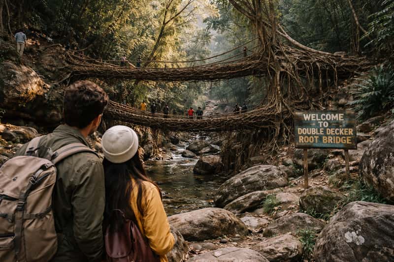
The Nongriat hike near Sohra is a steep stepped descent, thousands of steps down and back, that rewards trekkers with the double decker living root bridge. Treat it as its own day, not a side trip squeezed into day five. In heavy rain the steps get dangerously slick, so skip it when the monsoon is at full force.
Mawryngkhang and Wari Chora for the Ambitious
The Mawryngkhang bamboo trek and Wari Chora canyon are the offbeat places in Meghalaya worth adding only on a seven-day trip. Both demand dry conditions and genuine stamina, and both punish anyone who shows up expecting a casual stroll.
Adjusting the Route for 3, 5, or 7 Days and by Season
Trip length changes the order, not the logic. Three days stays on the Shillong to Sohra axis: base in Shillong, day-trip Sohra, skip Dawki and Mawlynnong to avoid the long southern legs. Five days runs the full loop above. Seven days adds a Nongriat day plus one offbeat trek like Mawryngkhang. The rule is simple: always move away from Shillong and only climb back once.
| Trip Length | Route | Skip / Add |
|---|---|---|
| 3 days | Shillong + Sohra day trip | Skip Dawki, Mawlynnong |
| 5 days | Shillong to Sohra to Dawki to Mawlynnong to Shillong | Full loop |
| 7 days | 5-day loop + Nongriat + one offbeat trek | Add Mawryngkhang or Wari Chora |
Best Time to Visit Meghalaya
October to April gives clear roads, the blue Umngot River, and open trails, which makes it the safe call for a first trip. June to September brings the heaviest rain and the fullest, most dramatic waterfalls, along with washout risk. Decide whether the trip wants dry conditions or peak water flow, then book to match.
When Rain, Road Washouts, and Festivals Change the Plan
Monsoon washouts near Dawki and the root bridge trailheads can close roads with little warning, so travelers in the wet months should keep the boat ride and Nongriat flexible. Festival windows in Shillong tighten guesthouse availability and push prices up, so those dates need booking weeks ahead. The rule: if forecasts show heavy rain on the Dawki day, flip Sohra and Dawki so the waterfall day lands in the downpour and the river day waits for a clearer window.
The Sequencing That Makes This Route Work
The famous stops are easy to find. The order that connects them without wasting a day is the actual work, and it is the part every top-30 list leaves out. Before closing the tab, a traveler should check the seven-day forecast for the Dawki leg and lock in a local driver for that stretch, because those two decisions shape the whole loop.
FAQs about Meghalaya places to visit
How many days does it take to see the best places to visit in Meghalaya?
Five days covers the core loop of Shillong, Sohra, Dawki, and Mawlynnong comfortably. Three days works on the Shillong to Sohra axis, and seven days allows Nongriat and an offbeat trek.
Which comes first, Shillong, Sohra, or Dawki?
Start in Shillong since travelers arrive there from Guwahati airport. Go to Sohra second, then drop south to Dawki, then Mawlynnong. This order avoids the backtracking that hurts most itineraries.
How long is the drive from Shillong to Sohra?
Shillong to Sohra (Cherrapunji) is about 55 km and takes roughly two hours with photo stops. Heavy rain can add another 30 minutes on the descent.
How far is Dawki from Sohra?
Sohra to Dawki runs roughly 80 km over three to three and a half hours on slower plains roads. The final approach into Dawki is rough, so a local driver helps.
Is Mawlynnong worth visiting?
Yes for first-timers and families wanting an easy cultural half day, since it is under an hour from Dawki. Travelers chasing bigger treks may prefer to trade it for an extra day near Sohra.
When is the best time to visit Meghalaya?
October to April gives clear roads, the blue Umngot River, and open trails. June to September brings the fullest waterfalls but heavy rain and washout risk near Dawki and the root bridges.
Can the Meghalaya circuit be self-driven?
It can, but a hired car with a local driver is smarter. The rough approaches near Dawki, the Sohra descent, and the root bridge trailheads are hard to work through solo, especially in fog or rain.
Are the living root bridges in Meghalaya hard to reach?
The single-decker bridge at Riwai near Mawlynnong is a gentle 10-minute walk suitable for families. The double decker bridge at Nongriat requires a steep stepped hike and needs its own day.
What is the best time of day for the Dawki Umngot River boat ride?
Mid-morning in the dry season, October to April, when light hits the clear water and the boat appears to float. In monsoon the river runs muddy and the effect is gone.
Can Meghalaya be done as a road trip?
Yes, the entire five-day loop is a single road trip of about 350 km and 11 to 12 hours of driving, one leg per day, with Shillong as the start and end point.